
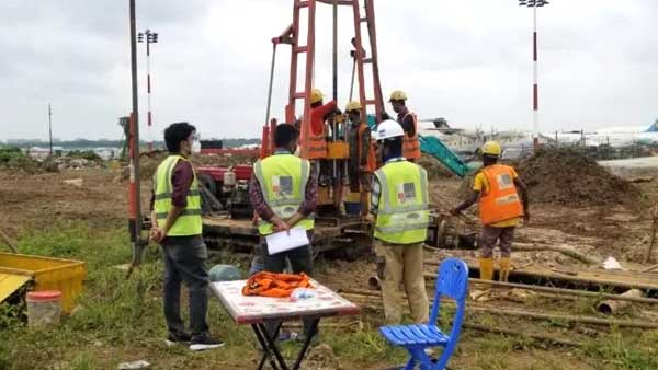
The Role of Geotechnical Testing in Bangladesh
Introduction
Every successful construction project begins with a solid understanding of the ground it will stand on. Whether it's a residential building, a bridge, a highway, or an industrial facility, the stability of the structure depends largely on the condition of the soil beneath it. That's where geotechnical investigation comes in.
Geotechnical investigation is the process of studying the physical and engineering properties of soil and rock before construction begins. It helps engineers understand how the ground will behave under different loads and environmental conditions, allowing them to design foundations that are safe, durable, and cost-effective. By examining factors such as soil strength, bearing capacity, groundwater levels, and subsurface layers, engineers can make informed decisions that reduce risks throughout the construction process.
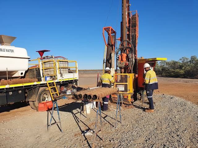
Skipping or minimizing geotechnical testing can have serious consequences. Weak or unsuitable soil conditions may lead to uneven settlement, cracked foundations, landslides, or even structural failure. As cities continue to expand and infrastructure projects become larger and more complex, the need for reliable geotechnical investigations has never been greater. Modern testing methods, including the Standard Penetration Test (SPT), Cone Penetration Test (CPT), and Seismic Cone Penetration Test (SCPT), provide engineers with the accurate data they need to build safer and more resilient structures.
Market Growth and Industry Trends
The geotechnical investigation industry has grown steadily over the past decade, driven by rapid urbanization, infrastructure expansion, and a stronger focus on construction safety. Governments, private developers, and engineering consultants now recognize that investing in a proper site investigation at the beginning of a project is far more economical than dealing with costly repairs or structural issues later.
Bangladesh is a good example of this growing demand. As the country continues to invest in highways, bridges, metro rail systems, ports, and commercial developments, geotechnical investigation has become a standard requirement for most major projects. Organizations such as the Local Government Engineering Department (LGED), Roads and Highways Department (RHD), RAJUK, Bangladesh Bridge Authority (BBA), Bangladesh Inland Water Transport Authority (BIWTA), Dhaka Mass Transit Company Limited (DMTCL), Public Works Department (PWD), Bangladesh Water Development Board (BWDB), HBRI, city corporations, port authorities, and the oil and gas sector regularly rely on geotechnical investigations before construction begins.
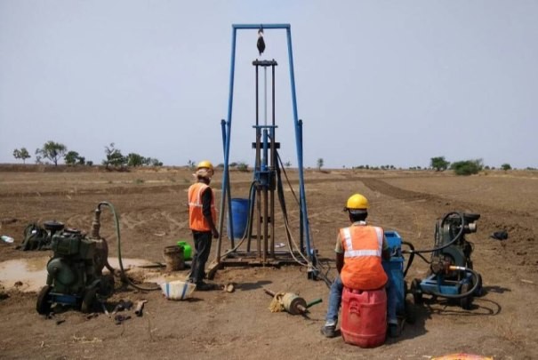
At the same time, advances in technology are transforming how investigations are carried out. Digital data logging, GPS-based positioning systems, GIS integration, automated testing equipment, and AI-assisted data interpretation are making investigations faster, more accurate, and easier to manage. These innovations not only improve efficiency but also help engineers make better decisions during the design stage.
Why Geotechnical Testing Is So Important
No two construction sites are exactly alike. Soil conditions can vary dramatically, even within the same project area. What looks like stable ground on the surface may hide soft clay, loose sand, or high groundwater levels beneath.
This is why geotechnical testing is such a critical part of any construction project. It allows engineers to determine whether a site is suitable for development, calculate the soil's bearing capacity, estimate future settlement, evaluate groundwater conditions, and identify weak layers that may require improvement.
The information gathered during testing plays a major role in selecting the right foundation system. It also helps reduce construction risks, avoid unexpected delays, optimize excavation work, and ensure compliance with engineering standards and building regulations. Ultimately, accurate soil data leads to safer structures and more efficient construction.
Key Geotechnical Investigation Techniques
Standard Penetration Test (SPT)
The Standard Penetration Test, commonly known as the SPT, remains one of the most widely used field tests in geotechnical engineering. Despite being a traditional method, it continues to provide reliable information that engineers use for foundation design around the world.
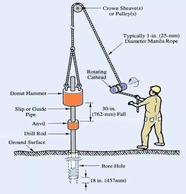
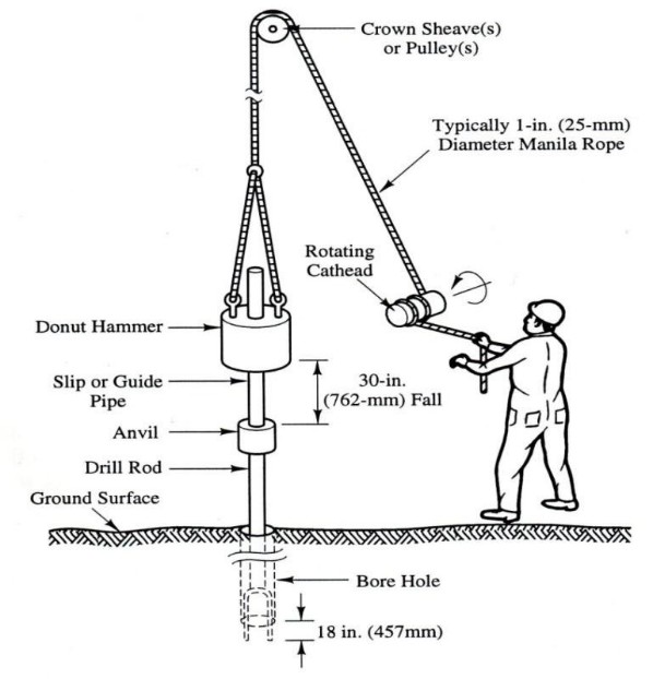
During the test, a borehole is drilled to the required depth, and a split-spoon sampler is lowered into the ground. A standard hammer is then used to drive the sampler into the soil. The number of hammer blows required to penetrate a specified distance is recorded as the SPT N-value.
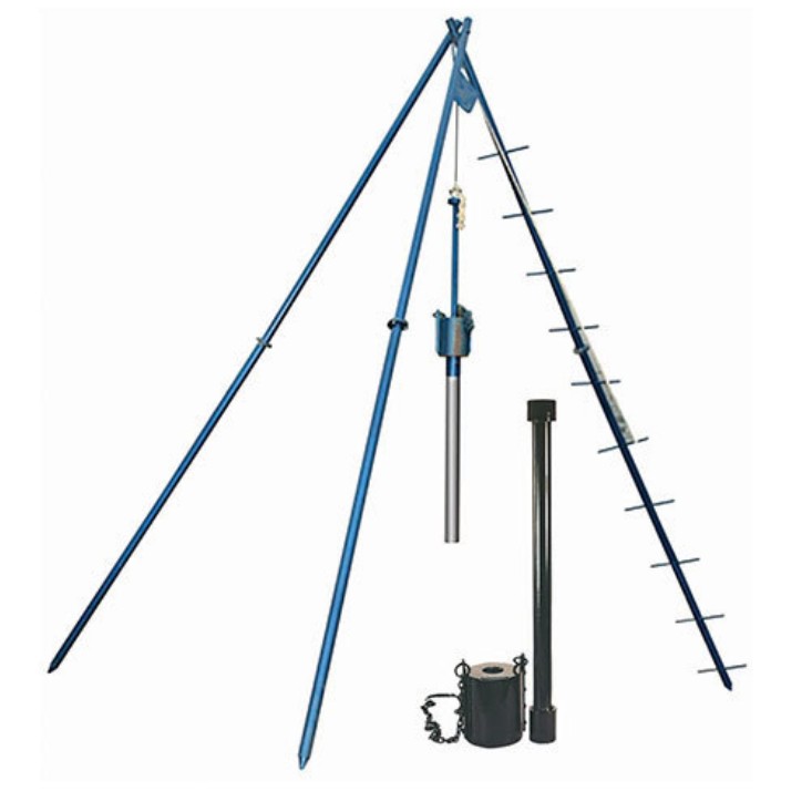
This simple procedure provides valuable information about soil density, consistency, bearing capacity, and stratification. It also allows engineers to collect soil samples, which are later tested in the laboratory to determine their engineering properties. Because of its reliability and extensive historical data, SPT remains one of the industry's most trusted investigation methods.
Cone Penetration Test (CPT)
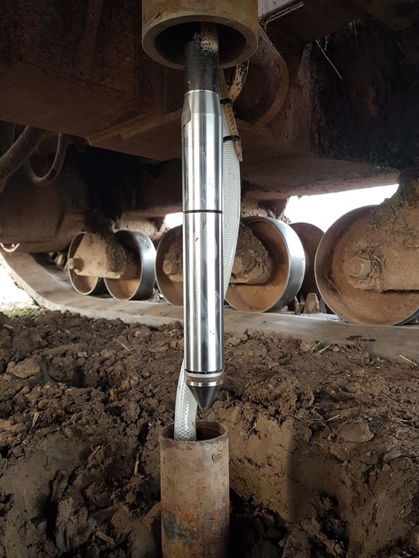
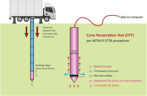
The Cone Penetration Test (CPT) represents a more advanced approach to site investigation. Instead of drilling a borehole, a cone-shaped probe is hydraulically pushed into the ground at a constant rate of approximately two centimeters per second.
As the cone penetrates the soil, sensors continuously record cone tip resistance, sleeve friction, and, when equipped, pore water pressure. Unlike SPT, which provides information at specific intervals, CPT delivers a continuous profile of subsurface conditions.
This continuous stream of data enables engineers to identify changes in soil layers more accurately and evaluate soil behavior in greater detail. Since the test requires little or no drilling, it is often faster and more economical, particularly for large infrastructure projects where numerous investigation points are needed.
Seismic Cone Penetration Test (SCPT)
The Seismic Cone Penetration Test builds upon the capabilities of CPT by incorporating seismic measurements into the investigation pro cess.
Special geophones installed inside the cone measure the travel time of seismic waves ge nerated at the g round surface. These measurements allow engineers to calculate shear wave velocity, which is a key parameter for evaluating the dynamic behavior of soil.
SCPT is especially valuable in regions where earthquake-resistant design is essential. It helps engineers determine seismic site classification, estimate soil stiffness, assess liquefaction potential, and design foundations capable of performing under dynamic loading conditions.
QC LAB SOLUTION Contribution to Geotechnical Investigation
QC LAB SOLUTION has become one of Bangladesh's trusted providers of professional geotechnical investigation services. By combining experienced engineers with modern testing equipment, the company supports a wide variety of infrastructure and development projects across the country.
Its services cover residential buildings, commercial developments, industrial facilities, bridges, highways, railways, ports, power plants, and water resource projects. Every investigation is carried out following recognized engineering standards to ensure reliable and accurate results.
The company's core services include conducting Standard Penetration Tests, Cone Penetration Tests, and Seismic Cone Penetration Tests using calibrated equipment. It also prepares detailed bore logs, develops subsurface soil profiles, performs comprehensive laboratory testing, and provides engineering recommendations for foundation design.
To improve project planning and data management, QC LAB SOLUTION also integrates digital reporting systems and GIS technology into its workflow. Combined with strict quality assurance and quality control procedures, these capabilities help clients make informed engineering decisions while reducing project risks.
Geotechnical Investigation Procedure
A successful geotechnical investigation follows a structured process to ensure that the collected data accurately represents the site's subsurface conditions.
The first stage involves site preparation. Engineers select suitable investigation points based on project requirements, clear the work area where necessary, and establish precise coordinates using GPS equipment.
For the Standard Penetration Test, boreholes are drilled to the required depth before lowering the split-spoon sampler into the soil. The sampler is driven using a standard hammer, and blow counts are recorded at every 15-centimeter interval. Disturbed soil samples are collected and carefully labeled before being transported to the laboratory.
The Cone Penetration Test follows a different approach. After positioning and leveling the CPT rig, the equipment is calibrated to ensure accurate measurements. The cone is then pushed into the soil at a constant speed while sensors continuously record cone resistance, sleeve friction, and pore pressure. These readings create a detailed and uninterrupted profile of the soil layers.
The Seismic Cone Penetration Test follows the CPT procedure but includes additional seismic measurements. Geophones embedded within the cone record the travel time of seismic waves generated by an external hammer or vibration source. From this information, engineers calculate shear wave velocity and other dynamic soil properties needed for earthquake-resistant design.
Throughout the investigation, strict quality control measures are followed. Instruments are regularly calibrated, sensor performance is verified, field readings are reviewed in real time, and standardized testing procedures are maintained to ensure consistent and reliable results.
Once fieldwork is complete, the collected soil samples undergo laboratory testing. Common tests include moisture content determination, grain size distribution, Atterberg limits, specific gravity, direct shear testing, consolidation testing, triaxial compression testing, permeability testing, compaction testing, and unconfined compression testing. Together, these tests provide the engineering parameters needed for foundation design.
The investigation concludes with a comprehensive geotechnical report containing bore logs, soil profiles, groundwater information, laboratory results, engineering analysis, foundation recommendations, and construction considerations. This report serves as the primary reference for structural and foundation engineers throughout the design process.
Working Step Geotechnical Investigations:
1. Site Preparation: Select test locations, clear vegetation, and establish baseline coordinates using GPS.
2. Standard Penetration Test (SPT):
- Borehole drilling to required depth.
- Insertion of split spoon sampler.
- Drop hammer to drive sampler and record blow counts at every 15 cm.
- Soil sample retrieval for lab testing.
3. Cone Penetration Test (CPT):
- Positioning of CPT rig and levelling.
- Hydraulic pushing of cone into soil at 2 cm/sec.
- Continuous measurement of tip resistance, sleeve friction, and pore pressure.
4. Seismic Cone Penetration Test (SCPT):
- Conduct CPT as above with geophone embedded.
- Use external seismic source to generate waves for SCPT.
- Measure shear wave velocity from travel time.
5. Data Logging and Quality Control: Review readings, check calibrations, and validate data in real time.
6. Laboratory Testing (For SPT): Analyse retrieved samples for Atterberg limits, grain size, and moisture content, Direct shear, Consolidation, Triaxial test and other LAB test.
7. Final Reporting: Create bore logs, CPT profiles, and interpret results to guide design recommendations.
Benefits of Geotechnical Investigation
A thorough geotechnical investigation offers significant advantages throughout a construction project's lifecycle.
Perhaps the greatest benefit is improved structural safety. Understanding soil conditions enables engineers to design foundations capable of safely supporting structural loads for many years.
Accurate soil information also leads to better foundation design. Instead of relying on assumptions, engineers can select the most suitable foundation type based on actual site conditions, improving both safety and cost efficiency.
Another major advantage is risk reduction. Identifying weak soil layers, soft clay deposits, loose sands, or groundwater issues before construction begins helps prevent unexpected prob lems that could delay the project or increase costs.
Although geotechnical investigations require an upfront investment, they often generate substantial long -term savings by reducing design revisions, construction delays, and expensive foundation repairs.
In addition, most major infrastructure projects require geotechnical investigations to comply with national building codes and engineering standards. Proper site investigations also support sustainable construction by minimizing unnecessary excavation, reducing material waste, and promoting more efficient use of resources.
Future of Geotechnical Investigation
As construction technology continues to evolve, geotechnical engineering is becoming increasingly data-driven and technology-focused.
Artificial intelligence is expected to improve the interpretation of complex soil data by identifying patterns and assisting engineers in predicting soil behavior more accurately.
Remote sensing technologies, including drones, satellite imagery, and LiDAR, will increasingly complement traditional field investigations by providing valuable geological and topographical information before work begins on site.
Automation is also changing the industry. Modern drilling rigs and CPT systems in Bangladesh now collect and process data automatically, reducing human error while improving efficiency and consistency.
Real-time cloud-based monitoring systems in Bangladesh allow engineers to access field data instantly, enabling quicker decision-making and more effective project management.
Looking ahead, three-dimensional subsurface imaging is expected to provide highly detailed underground models that improve visualization of complex geological conditions. At the same time, integrating geotechnical data into Building Information Modeling (BIM) in Bangladesh platforms will strengthen collaboration between architects, structural engineers, geotechnical specialists, and construction managers.
Conclusion
Geotechnical investigation is far more than a routine site assessment—it is the foundation of safe, efficient, and sustainable construction. Understanding what lies beneath the ground allows engineers to design foundations that perform reliably throughout the life of a structure while reducing risks, controlling costs, and ensuring long-term safety.
Testing methods such as the Standard Penetration Test (SPT), Cone Penetration Test (CPT), and Seismic Cone Penetration Test (SCPT) provide the detailed information needed to evaluate soil strength, stratification, and dynamic behavior. Together, these investigations give engineers the confidence to make informed design decisions and address potential ground-related challenges before construction begins.
As Bangladesh continues to invest in modern infrastructure, organizations like QC LAB SOLUTION are playing an important role by delivering reliable geotechnical investigation services supported by experienced professionals, advanced equipment, digital technologies, and internationally recognized testing standards.
With ongoing developments in artificial intelligence, automation, GIS, remote sensing, and real-time data analysis, geotechnical investigation will continue to evolve. These innovations will not only improve the accuracy and efficiency of site investigations but also contribute to safer buildings, stronger infrastructure, and more sustainable development for years to come.