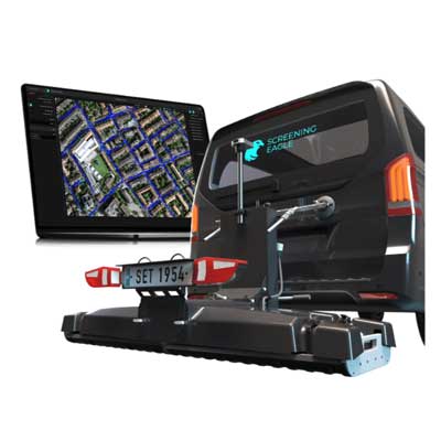
GPR GM8000 Subsurface Mapping

GPR GM8000 Subsurface Mapping

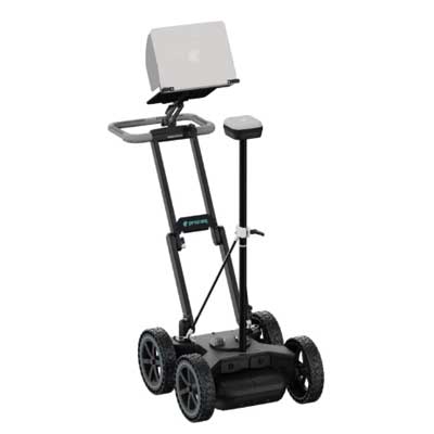
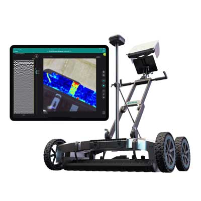
Modular multichannel GPR mobile mapping system for the subsurface Interchangeable GPR arrays with high speed dynamic range The highest density of information, accurately mapped in 3D Virtually limitless data management and computational power
  • Highlights
  • Features
  • Specification
  • Models
  • Standards
  • Review (2)

GPR GM8000 Subsurface Mapping Price in Bangladesh

The GPR GM8000 is a professional ground penetrating radar system designed for subsurface investigation, making GPR GM8000 Subsurface Mapping Price in Bangladesh a relevant search for engineers, surveyors, contractors, and infrastructure professionals. Designed for non destructive underground mapping, it helps users investigate buried structures and subsurface conditions while reducing the need for unnecessary excavation.

The GPR GM8000 supports ground penetrating radar surveys for locating and evaluating underground features. It can help professionals identify buried utilities, pipes, cables, voids, foundations, and other subsurface objects. This makes it useful for construction planning, infrastructure inspection, utility surveys, road investigation, and general site assessment.

Designed for professional field applications, the GPR GM8000 combines practical usability with advanced subsurface detection capabilities. Its field oriented construction allows survey teams to work efficiently across construction sites, roads, pavements, industrial areas, and other challenging locations. The system supports the collection of valuable underground information without causing significant disruption to existing surfaces.

Subsurface mapping is an important part of modern construction and civil engineering projects. Reliable underground information can help professionals plan excavation, reduce the risk of damaging buried utilities, investigate unknown structures, and make informed decisions before beginning construction or maintenance activities.

The GPR GM8000 is suitable for civil engineers, geophysical surveyors, utility detection specialists, construction companies, infrastructure contractors, researchers, and site investigation teams. Its combination of ground penetrating radar technology, non destructive surveying, practical field operation, and durable professional design makes it a valuable solution for reliable subsurface mapping and underground investigation.


N/A

Tech Specs

Radar technology

Stepped-frequency GPR


Modulated frequency range

500 – 3000 MHz ² | 30 – 750 MHz ³


Number of channels

71 (VV) + 31 (HH) ² | 23 (VV) ³


Channel spacing

2.5 cm (VV), 5.5 cm (HH) ² | 7.5 cm ³


Scan width

1.75 m ² | 1.67 m ³


Scan rate

27500 scans/s ² | 22000 scans/s ³


Time window

45 ns ² | 130 ns ³


Acquisition speed

Up to 80 Km/h ² ⁴ | Up to 180 Km/h ³ ⁵


Spatial interval

Up to 100 scans/m


Dimensions

Total length: 923 mm | Total width: 1882 mm


Weight

87 - 93 Kg ¹⁰


Odometry

Doppler radar or wheel speed sensor


Ingress protection (IP) / sealing

IP65


Towing system

Rear hitch, 50 mm ball


Shock absorption system

Hydraulic, optional anti-bump wheels


Power supply

Power-over-Ethernet / External 12V


Operating temperature

-10° to 50°C | 14° to 122° F


Operating humidity

<95% RH, non-condensing


Connectivity

USB-C, USB-A, 2x Ethernet + Power, 2x Lemo ⁶, 2x ODU Antenna connector, Universal I/O (UART, CAN-Bus)


GNSS satellites

Multiband GPS + Glonass + Galileo + Beidou


GNSS real-time corrections

NTRIP RTK compatible ⁷


RTK accuracy

Typ. 1 - 5 cm | 0.5 - 2 in ⁸


RTK outage accuracy

<0.1% drift/distance ⁹


Sensor fusion

GNSS + IMU + Camera imaging + Wheel speed


Feature tracking

Yes

1. Running an up-to-date iOS version; recommended models: MacBook Pro® 2022 model or superior
2. In combination with 2x GX1 array modules
3. In combination with 2x GX2 array modules
4. At 100mm spacing
5. At 50mm spacing
6. For terrestrial positioning systems, an intermediate serial adapter to DB9 might be needed to output Pseudo NMEA GGA positions
7. Needs an active Internet connection on the iPad; NTRIP corrections in RTCM3 format
8. The achieved accuracy is subject to atmospheric conditions, satellite geometry, observation time, etc.
9. By bundle adjustment between fixed RTK positions. Estimated max. error: 0.3 m in floating RTK sections./
10. Depending on configuration and accessories, cables included

N/A

N/A

2 Reviews For win Your Friends

Add Your Review

Your Rating:
Steven Rich – Sep 17, 2016:
How all this mistaken idea of denouncing pleasure and praising pain was born and I will give you a complete account of the system, and expound the actual teachings.
William Cobus – Aug 21, 2016:
There anyone who loves or pursues or desires to obtain pain itself, because it is pain sed, because occasionally circumstances occur some great pleasure.

Any question about the GPR GM8000 Subsurface Mapping ?

* indicates required fields

CAPTCHA