
Ground Penetrating Radar (GPR) Survey in Bangladesh for Subsurface Investigation
Modern construction and infrastructure projects require reliable information about conditions below the ground, and Ground Penetrating Radar (GPR) Survey in Bangladesh provides a practical non destructive method for investigating subsurface features. GPR technology uses electromagnetic signals to identify changes in underground materials and can help locate buried utilities, concrete structures, voids, pipes, reinforcement, and other subsurface targets. Unlike conventional excavation, GPR investigation can collect information without immediately disturbing the surface. This makes it useful for buildings, roads, bridges, industrial facilities, utility corridors, and other developed areas. Engineers and survey professionals can use GPR data to improve planning and reduce uncertainty before drilling, cutting, excavation, or construction. The quality of results depends on equipment selection, site conditions, material properties, target characteristics, survey design, and professional interpretation. A properly conducted GPR survey combines field scanning with technical analysis to develop a clearer understanding of subsurface conditions. This approach can support safer construction activities, better asset management, and more informed engineering decisions while helping reduce the risk of unexpected underground obstructions.
Market Landscape and Demand Growth
Market Trends
Globally, the demand for utility surveys is rising sharply, driven by complex infrastructure networks and a push for safer, smarter cities. GPR is increasingly used by construction firms, urban planners, utility companies, and infrastructure authorities.
Growth Drivers
Factors like rapid urbanization, frequent infrastructure upgrades, and a focus on reducing construction hazards have accelerated the adoption of GPR. Innovations in radar technology, software, and integration with GIS platforms are set to drive this momentum further.
Key Technologies in Subsurface Mapping
- GPR (Ground Penetrating Radar): The primary tool for identifying various buried assets. GPR enables high-resolution, real-time imaging, ideal for utility detection.
- EMI (Electromagnetic Induction): Effective for identifying metallic or conductive utilities. When combined with GPR, it enhances detection accuracy.
- LiDAR (Light Detection and Ranging): While not directly for utility detection, it complements GPR by delivering 3D surface models, supporting more holistic surveys.
Digital Integration and Smart Infrastructure
As cities embrace digital transformation, utility mapping is becoming a key component of smart infrastructure planning. Integrating GPR survey data into digital platforms helps create more accessible, real-time infrastructure management systems.
- GIS Integration: Subsurface utility data can be mapped and stored in geographic information systems for better coordination across construction, maintenance, and planning teams.
- Mobile and Software Solutions: GPR-collected data can be used to develop applications that deliver utility maps and alerts in real-time, enhancing safety and reducing delays in fieldwork.
- Smart City Planning: Accurate utility mapping is critical to avoid accidental damage during infrastructure upgrades and ensures smarter, more sustainable urban development.
Underground Utility Detection Using GPR
Underground utility detection is one of the most useful applications of Ground Penetrating Radar. Construction sites may contain buried water pipes, drainage lines, electrical conduits, communication ducts, gas lines, and other services. Some utilities may not have reliable records, while older infrastructure can differ from available drawings. GPR scanning can help identify subsurface anomalies that may represent buried services or other objects. Engineers can map detected features and combine the findings with available utility drawings, surface indicators, and other survey information. This can improve planning before excavation or drilling. GPR is especially useful for detecting non metallic objects that may be difficult to identify using methods designed mainly for conductive materials. However, detection capability depends on depth, material, soil condition, target size, orientation, and electromagnetic properties. GPR should therefore be considered part of a comprehensive utility investigation rather than a universal replacement for all detection methods. Where appropriate, GPR can be combined with electromagnetic locating, records review, trial excavation, or other verification techniques. A professional utility survey helps construction teams identify potential underground risks and select safer excavation and installation strategies.
Test Procedure for GPR Utility Surveys
-
- Preparation: Survey site is assessed and GPR equipment is calibrated based on local soil conditions and target utility
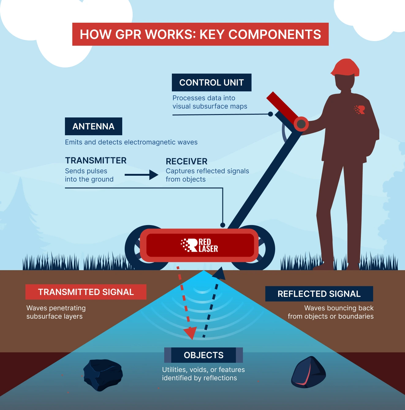
- Survey Execution: The GPR unit—often mounted on a cart—is rolled over the area, emitting radar pulses and recording reflections.
- Data Collection: Subsurface reflections are captured by the system and stored for processing.
- Analysis:
Specialists analyze the radar data to identify utilities, voids, or other subsurface features.
- Reporting: Final reports include maps and diagrams showing the
location, depth, and condition of utilities, along with any anomalies or recommended actions.
Key Benefits of Using GPR in Utility Surveys
- Non-Invasive: No need for excavation, minimizing surface disruption.
- Real-Time Feedback: Instant results help decision-makers act quickly and efficiently.
- High Accuracy: Pinpoints utility location, depth, and orientation with precision.
- Cost-Effective: Reduces costs related to manual digging and utility damage.
- Multi-Utility Detection: Identifies water, gas, electricity, telecom, and other underground systems in a single survey.
Ground Penetrating Radar has revolutionized the field of utility surveying, offering a reliable, non-invasive, and highly accurate way to map the subsurface utility detection. As the need for efficient infrastructure management grows, the adoption of GPR will continue to expand globally. From improving construction safety to enabling smart city development, GPR stands as a critical tool for modern utility management and digital transformation.
Importance of GPR Survey for Construction Projects
Construction work can become complicated when underground conditions are not properly understood before excavation or structural modification. Existing utilities, pipes, cables, foundations, reinforcement, voids, and abandoned structures may not be clearly visible from the surface. Ground Penetrating Radar Survey help s engineers investigate these hidden features and develop a better picture of the site. This information is valuable before foundation work, road excavation, utility installation, drilling, concrete cutting, and other intrusive activities. Identifying potential obstacles early can help reduce accidental damage and improve work planning. GPR can also support investigations in areas where excavation is difficult, expensive, or undesirable. For existing buildings, the technology can help identify concealed structural elements and embedded components before modification. Survey results should always be interpreted according to the limitations of the method because radar performance varies with soil and material conditions. Nevertheless, when appropriately selected and executed, GPR provides useful subsurface information without requiring widespread excavation. It is therefore an important investigation tool for construction professionals seeking to improve site knowledge and reduce uncertainty during project development.
GPR Concrete Scanning and Structural Investigation
GPR technology is also widely used for investigating reinforced concrete structures. Concrete slabs, walls, beams, columns, bridge decks, and other elements may contain reinforcement, conduits, post tensioning components, embedded pipes, or other concealed features. Before drilling or coring, engineers can use GPR scanning to identify the location and pattern of internal elements. This reduces the likelihood of accidentally damaging reinforcement or embedded services. Concrete scanning can also help assess structural arrangements when original drawings are incomplete or unavailable. Radar signals interact with changes in material properties, allowing trained professionals to interpret reflections associated with embedded objects and interfaces. The effectiveness of concrete GPR depends on concrete composition, reinforcement density, moisture, surface condition, target depth, and antenna frequency. Different antenna configurations may be selected according to the required resolution and investigation depth. GPR results should be interpreted by experienced personnel who understand both radar behavior and structural construction. When integrated with drawings, visual inspection, and other testing methods, concrete scanning provides valuable information for repair, renovation, drilling, coring, and structural modification projects.
Rebar Detection with Ground Penetrating Radar
Reinforcement detection is an important part of many concrete investigation projects. Steel reinforcement is commonly embedded within slabs, beams, columns, walls, foundations, and bridge structures. Knowing reinforcement location and spacing can help engineers plan drilling, coring, cutting, repair, and strengthening activities. Ground Penetrating Radar can scan concrete surfaces and identify reflections associated with reinforcing bars and other embedded objects. Survey professionals can use the collected data to develop reinforcement maps showing approximate locations and patterns. This information can also support structural assessment when original reinforcement drawings are unavailable. GPR interpretation requires consideration of signal reflections, bar orientation, concrete properties, and surrounding reinforcement density. Closely spaced reinforcement can make individual targets more difficult to distinguish. Therefore, results should be reviewed carefully and, where necessary, verified through complementary investigation. GPR does not directly replace structural design documentation or provide every property of reinforcement. Its main value is in locating and characterizing subsurface features that affect engineering decisions. Proper reinforcement mapping can improve construction safety and help prevent unnecessary damage to structural components during intrusive work.
Void and Cavity Detection with GPR
Subsurface voids and cavities can create serious concerns for buildings, roads, pavements, and other infrastructure. They may develop because of soil erosion, poor compaction, leakage, abandoned structures, settlement, or changes in underground conditions. Ground Penetrating Radar can help identify areas where subsurface electromagnetic responses differ from surrounding materials. Such anomalies may indicate voids, disturbed soil, buried objects, or changes in material composition. GPR investigation can therefore support preliminary identification of suspicious areas before further verification. The method is particularly useful for scanning large surfaces such as floors, pavements, and open ground. However, radar interpretation must account for local geology and soil conditions because not every anomaly represents a cavity. High moisture, conductive soil, fill material, and complex underground conditions can affect signal penetration and clarity. When a potentially significant anomaly is identified, engineers may recommend targeted verification using drilling, excavation, boreholes, or other appropriate methods. GPR is most effective when used as part of a broader engineering investigation. It can help focus intrusive testing on specific areas and reduce unnecessary disturbance to otherwise sound surfaces.
GPR Survey for Roads and Pavements
Roads and pavements contain multiple layers that may change because of construction history, traffic loading, moisture, repairs, and deterioration. GPR can provide useful information about pavement layer interfaces and subsurface anomalies without requiring continuous excavation. Engineers can use radar scanning to investigate pavement thickness variations, buried features, voids, and changes in material conditions. This information can support maintenance planning and rehabilitation design. GPR is also useful for locating buried utilities and structures beneath road surfaces before excavation or cutting. For large transportation projects, continuous or closely spaced scanning can provide extensive subsurface data more efficiently than repeated trial pits alone. The collected radar profiles can be analyzed to identify changes in layer response and areas requiring further investigation. Results should be correlated with known site information and, where necessary, verified using cores or other direct measurements. Environmental and soil conditions can influence radar penetration, so survey planning should consider the expected subsurface materials. Properly applied, GPR provides transportation engineers with a valuable non destructive investigation method for understanding pavement and road conditions.
GPR Survey for Building and Foundation Investigation
Existing buildings may contain concealed foundations, slabs, walls, footings, utilities, and other subsurface or embedded features that are not clearly documented. GPR can assist engineers in investigating these elements before renovation, extension, strengthening, or demolition. Foundation investigations may use radar scanning to identify changes beneath accessible surfaces and to locate potential structural or buried features. In buildings with incomplete records, GPR can provide supplementary information about construction arrangements. It may also help identify buried pipes, ducts, voids, and changes in floor construction. For renovation projects, understanding the existing building configuration is important because new work must often connect with or avoid existing structural components. GPR can reduce uncertainty before drilling and cutting and help engineers plan targeted intrusive investigations. However, foundation conditions are complex, and radar alone cannot establish all soil or structural properties. Geotechnical investigation, structural assessment, or direct verification may still be required depending on project objectives. GPR is therefore best used as a complementary investigation method that adds subsurface information to the overall engineering assessment.
Non Destructive Testing with GPR Technology
Ground Penetrating Radar is considered a non destructive investigation technique because it can examine subsurface conditions without requiring extensive physical removal of material. This characteristic makes it valuable for existing structures and finished surfaces where damage must be minimized. GPR scanning can be performed over concrete, asphalt, soil, floors, walls, and other suitable surfaces depending on the equipment and survey objective. The collected signals are processed and interpreted to identify changes that may correspond to buried or embedded features. Non destructive investigation is particularly useful when the surface has architectural, historical, operational, or structural importance. It allows engineers to obtain additional information before deciding where intrusive testing is necessary. This can reduce unnecessary drilling, cutting, and excavation. However, non destructive does not mean that every subsurface feature can always be detected. Material conductivity, moisture, target depth, clutter, surface condition, and signal interference can limit performance. Professional survey planning is therefore essential. Engineers should define the investigation objective before selecting the equipment and scanning method. Proper GPR use provides useful evidence while preserving the condition of the investigated surface.
GPR Data Collection and Survey Methodology
A successful GPR investigation begins with a clear understanding of the survey objective. Engineers first review available drawings, site information, construction history, and known subsurface features. The survey area is then prepared and suitable scanning paths are established. Antenna frequency and equipment configuration are selected according to the expected target depth, required resolution, and surface conditions. During fieldwork, radar data is collected along planned profiles while maintaining consistent scanning procedures. Important surface features may be marked or surveyed so that detected anomalies can be related to physical locations. Data quality checks are performed during acquisition to identify areas that may require additional scanning. After field collection, radar profiles are processed and interpreted using appropriate software and engineering judgment. Significant anomalies can be mapped and presented in a clear survey report. Where exact depth or target identification is important, additional verification may be recommended. The methodology should remain focused on the engineering question rather than simply collecting large quantities of data. A well planned GPR survey produces information that is easier to interpret and more useful for construction, structural assessment, and infrastructure management.
GPR Survey for Utility Mapping and Safe Excavation
Safe excavation requires accurate knowledge of potential underground obstacles. Utility mapping using GPR can support excavation planning by identifying possible buried services and other subsurface anomalies. This is particularly important in developed areas where multiple generations of infrastructure may exist below the surface. Before trenching, drilling, piling, or foundation excavation, survey information can help construction teams understand where potential obstacles may be located. GPR findings can be combined with utility records, surface observations, electromagnetic locating, and targeted verification. The resulting information can be transferred to site drawings or marked on the ground according to project requirements. Utility mapping does not guarantee that every underground service will be detected because conditions can limit radar performance. Therefore, safe excavation procedures should continue to include appropriate verification and site controls. GPR is most valuable when it forms part of a broader risk reduction strategy. By improving knowledge of subsurface conditions before intrusive work, it can help reduce accidental utility strikes, project delays, service interruptions, and unnecessary excavation. Professional interpretation is essential to distinguish likely utilities from other underground features.
GPR Survey for Industrial and Infrastructure Facilities
Industrial facilities often contain complex underground and embedded infrastructure developed over many years. Pipes, cables, drainage systems, foundations, tanks, conduits, ducts, and reinforced concrete structures may exist beneath operational areas. GPR can assist facility managers and engineers in mapping these features before maintenance, modification, or expansion work. It is useful when existing drawings are incomplete or when previous construction has changed the original arrangement. Industrial surveys may cover floors, yards, roads, foundations, equipment bases, and other accessible areas. GPR information can support decisions about drilling, anchoring, excavation, foundation construction, and utility modification. In infrastructure projects, the technology can also help investigate bridge decks, pavements, tunnels, retaining structures, and other constructed assets. Survey requirements vary significantly between projects, so the investigation should be designed around the expected targets and engineering objectives. Data should be clearly documented and referenced to site coordinates or identifiable physical locations. When properly integrated with structural and civil engineering information, GPR provides useful subsurface insight while limiting the need for widespread destructive investigation.
Limitations of Ground Penetrating Radar Survey
Understanding the limitations of GPR is essential for responsible engineering interpretation. Radar signals can be strongly affected by material conductivity, moisture, clay content, reinforcement density, surface condition, target size, target depth, and surrounding structures. Highly conductive soils or materials can significantly reduce signal penetration. Closely spaced metal reinforcement can also create complex reflections that make deeper targets difficult to identify. A radar response may indicate a subsurface change without proving exactly what material or object caused it. For this reason, GPR findings should not be interpreted beyond the evidence available from the survey. Engineers may recommend complementary techniques when important decisions depend on target confirmation. These can include trial excavation, core sampling, electromagnetic locating, drilling, visual inspection, or other appropriate methods. Survey quality also depends on operator experience, equipment selection, data processing, and site preparation. A professional report should clearly state the survey scope, detected features, interpretation, and limitations. Recognizing these limitations does not reduce the value of GPR. Instead, it ensures that the technology is used correctly and that its findings are integrated into a broader engineering investigation when necessary.
Benefits of Professional GPR Survey Services in Bangladesh
Professional Ground Penetrating Radar (GPR) Survey in Bangladesh can provide significant benefits for construction, structural investigation, infrastructure development, and facility management. The non destructive nature of the technology allows engineers to investigate many surfaces without immediate excavation or physical damage. GPR can help locate buried utilities, identify reinforcement, investigate voids, map subsurface features, and support condition assessment. Early information can help project teams plan drilling, cutting, excavation, and construction activities more safely. It can also reduce uncertainty when existing drawings are incomplete or unreliable. The technology is suitable for many environments, includin g buildings, roads, industrial sites, bridges, and utility corridors, provided that site conditions are suitable. Professional services should include appropriate equipment selection, systematic scanning, data quality control, experienced interpretation, and clear reporting. The final objective is not simply to produce radar images but to provide useful engineering information that supports practical decisions. When combined with other survey and testing methods, GPR can become an effective part of a modern subsurface investigation program. Its value is greatest when the survey is carefully planned around the actual risks and technical requirements of the project.
Choosing a Reliable GPR Survey Service
Choosing a reliable GPR survey provider is important because the quality of subsurface information depends on more than the equipment itself. A competent service provider should understand radar principles, construction practices, structural systems, utility environments, and engineering investigation methods. The team should select appropriate equipment based on the expected target depth, surface material, and required resolution. Field personnel should follow systematic scanning procedures and maintain clear location references for collected data. Data interpretation should be performed by professionals who can distinguish likely targets from uncertain anomalies and explain the limitations of the findings. A useful report should present the survey area, methodology, important observations, interpreted features, and recommendations for further verification where required. Communication with the project team is also important because GPR results often need to be integrated with architectural drawings, structural plans, utility records, and construction information. For projects in Bangladesh, local site experience can further help survey teams understand common construction and infrastructure conditions. A professional GPR service ultimately provides more than underground images. It delivers practical subsurface information that can support safer work, better planning, and more confident engineering decisions.